Trailz – Let’s Ride!
- 2.3
- Rating
- 10.00K
- Installs
- Free
- Price

 Analysis by App-foxy
Choosing a navigation app for an ATV, UTV, or snowmobile is different from choosing one for a daily car commute. I do not mainly want the quickest route between two addresses. I want a tool that makes trail planning easier, remains understandable when the route leaves ordinary roads, and does not get in the way when I am wearing gloves, dealing with changing weather, or stopping to check where I am. That is the space Trailz – Let’s Ride! tries to occupy.
This is a free Maps & Navigation app from Patric L Kranz, aimed specifically at off-road recreation. Its store summary focuses on ATV, UTV, and snowmobile adventures, while the short description simply calls it “Trailz.” That narrow focus is important: I would not install it as my only navigation tool for every kind of trip. I would consider it when the journey itself is the point and ordinary map apps feel too centered on streets, addresses, and turn-by-turn driving.
My overall view is cautious but interested. The concept is much more relevant to trail riders than a standard road map, yet the modest store reception matters. It has a 2.3 average from around twenty ratings and roughly nine written reviews, with over ten thousand installs. Those numbers do not define the whole experience, but they do tell me to approach it as a specialized tool that deserves testing before I depend on it far from help.
You May Also Like

 Pandora - Music & Podcasts
Pandora’s Music Is Easy to Start, but Harder to Recover
Pandora’s strength is its low-effort path from a seed to a station. Its weak spot is how much confidence it asks you to place in connection, setup, and quiet recovery.

 AccuWeather: Weather Radar
AccuWeather Review: A Quick, Clear Forecast for Everyday Decisions
For everyday plans, the best forecast is the one you can understand quickly. AccuWeather makes rain timing, radar, and local conditions easy to act on, with a few trade-offs.

 Hill Climb Racing
Why Hill Climb Racing Still Turns Crashes Into One More Run
A tiny car, a bumpy hill and one more upgrade: Hill Climb Racing keeps resurfacing because its simple chaos makes every near-miss feel personal.

 AliExpress - Shopping App
AliExpress Makes Global Shopping Feel Personal, but Shoppers Bear the Risk
AliExpress turns a global marketplace into a pocket-sized discovery engine. Its reach is useful, its shopping loop compelling, and its trade-offs easy to miss.

 Lords Mobile: Kingdom Wars
Lords Mobile Is a Kingdom-Building Routine, Not a Quick Match
A case-by-case verdict on the building, battles, device demands, and social commitments that make Lords Mobile rewarding for some players and exhausting for others.

 PDF Scanner app - TapScanner
TapScanner Makes Paperwork Easier to Capture, Check, and Share
TapScanner makes scanning with a phone feel less like a rescue operation and more like a dependable step in getting work done. Its capture tools are useful, though not flawless.
More From Our News Desk
View All News


What I would judge before taking Trailz on a ride
The first decision is not whether the interface looks attractive. It is whether the app matches the kind of navigation problem I actually have. If I am riding a familiar local loop and only need a broad sense of position, a dedicated trail app can be useful. If I need verified closures, highly detailed land-access information, dependable offline operation, or a complete emergency plan, I would want to examine those areas carefully before replacing my current setup.
I would also separate route discovery from route safety. An app can help me understand where I am without proving that every visible line is legal, open, suitable for my vehicle, or safe in current conditions. That distinction is especially important for snowmobile trips, where seasonal access can change, and for ATV or UTV riding, where a narrow track may be unsuitable for a larger machine. I would treat Trailz as one part of preparation rather than as permission to enter every path shown on a screen.
Ease of use is another practical test. On a ride, I may be looking at the phone briefly rather than studying it for several minutes. A useful workflow should let me prepare before leaving, recognize my position quickly, and return me to the route without unnecessary tapping. I would test those actions at home and in a nearby riding area first. That small trial is more valuable than judging the app from its store summary.
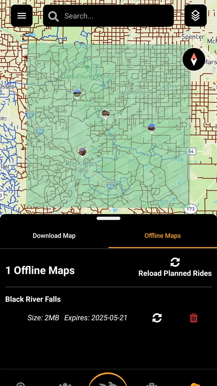
Device compatibility is relatively broad on the Android side because the app supports Android 7.0 and later. That makes it possible to use an older spare phone instead of risking a newer daily device on dust, cold, or vibration. Still, an older phone may have a weaker battery, dimmer display, or slower location response, so the operating-system requirement is only the starting point. I would check the actual phone, case, mount, and charging arrangement as a complete system.
Preparation matters more than the first screen
My preferred workflow would be to open the app before the ride, inspect the intended area while I have a stable connection, and note the important turns or meeting points. I would then carry a backup such as a paper map, a second navigation method, or a route shared with someone at home. This is not a criticism unique to Trailz; outdoor navigation always benefits from redundancy. The difference is that a specialized app can encourage better trail-focused preparation than a general road map.
I would avoid treating the phone display as the sole source of direction. Glare, mud, rain, snow, and thick gloves can make a touchscreen inconvenient. I would mount the phone where it can be glanced at without blocking the trail, keep the route review short, and stop safely before changing anything. The best navigation app is still a poor riding companion if it encourages constant screen use while moving.
One useful test is to deliberately follow a short, familiar section and compare what I see on the ground with what the app shows. I would look for differences between a visible track and the route line, confusing junctions, and places where the map encourages a turn that is physically difficult for my machine. This kind of local validation gives me more confidence than immediately taking the app into an unfamiliar backcountry area.
Where Trailz earns its place
The strongest argument for this app is its identity. It is not presented as a broad travel planner or a city-navigation replacement; it is built around off-road trail navigation. That focus can make a difference for riders who find ordinary map applications too focused on paved roads. When I am planning a recreational outing, I want the map conversation to begin with trails and riding context rather than with traffic and addresses.
I also like the possibility of using a spare or older Android phone for a dedicated riding setup. Because the app is free to install, the initial experiment is less financially demanding than committing to specialized hardware immediately. That does not remove the need to check the in-app purchase screen, but it lowers the barrier to testing the basic experience on a device I already own.
The app’s audience is clearly defined enough to help with trip planning. An ATV rider, a UTV group leader, and a snowmobile enthusiast may have different machines, but all need to think about route continuity, junctions, and staying oriented away from regular roads. A purpose-built tool can be more comfortable for that mindset than a general-purpose navigation app that treats the trail as an incidental line.
Another advantage is the chance to keep route awareness in one place instead of switching repeatedly between a road map, a saved note, and a separate trail reference. I would particularly value that during a day with several loops or a meeting point where a group needs to regroup. Even without making assumptions about every feature, the central idea is useful: the app is designed for the navigation problem I am actually trying to solve.
Three practical habits that improve the experience
First, I would create a pre-ride check that has nothing to do with speed. I would open the route, identify the exit points, note where the group could turn back, and confirm that the intended line matches the vehicle and the day’s conditions. This turns the app from a screen I consult only after getting confused into a planning tool I use before the engine starts.
Second, I would use it as a group coordination aid without assuming that everyone sees the same thing. Before leaving, I would agree on a simple meeting location and a fallback plan. If one rider loses battery or signal, the group should still know where to regroup. A navigation app is much more useful when it supports a shared plan instead of becoming the only plan.
Third, I would compare the displayed route with local knowledge after every unfamiliar ride. If a track is closed, rougher than expected, or unsuitable for a UTV, I would record that lesson for the next trip rather than blindly trusting the same line again. This is a subtle but important trade-off: a digital route can remain visually persuasive even after real-world conditions change.
Those habits are especially valuable because the app has a relatively small rating history. With an average of 2.3, I would not dismiss it automatically, but I would be more deliberate about testing. A specialist app may suit my particular riding area while disappointing another user whose expectations are different. The right response is a short, controlled trial rather than immediate dependence or immediate rejection.
What the price really means
Trailz is free to install, which makes it approachable for a rider who wants to explore the idea without paying before seeing whether the workflow fits. However, in-app purchases range from $9.99 to $59.99 per item. That means “free” should be understood as a low-risk starting point, not as a guarantee that every useful part of a long-term setup will remain free.
I would inspect the purchase screen before planning a major trip. I would want to know exactly which part of my intended workflow requires payment, whether it affects the areas or tools I care about, and whether the purchase is essential for the way I ride. Since the available items span a wide range, the cost decision could be reasonable for a frequent rider but harder to justify for someone who only takes occasional outings.
My advice would be to test the free experience on a familiar route first. If the app already feels awkward there, paying will not solve the basic usability problem. If it feels natural and the paid capability directly addresses a repeated need, then the purchase becomes easier to judge as a practical riding expense rather than an impulse buy.
Where another navigation approach may fit better
I would choose a general road-navigation app instead when my trip is mostly about reaching a trailhead, campground, fuel stop, repair shop, or town. Those apps are usually built around addresses and road travel, so they are often the more sensible tool for the paved part of the journey. Trailz may complement that process rather than replace it: one app for getting to the riding area and a trail-focused option for the recreational section.
I would also look toward a different solution if my priority is authoritative land-access information. A route line alone does not answer whether a trail is currently open, whether a permit is needed, or whether a vehicle class is allowed. For that, I would consult the relevant local authority, riding club, land manager, or current trail bulletin. The best combination may be official information for legality and conditions, with Trailz used for orientation.
Dedicated outdoor navigation hardware may be better for riders who spend long days away from charging, expose equipment to harsh weather, or need a larger and more rugged display. I would not assume that a phone app can match a purpose-built device in durability or battery management. On the other hand, hardware costs more and is less flexible, so a casual rider may reasonably prefer to begin with an existing Android phone and see whether the app meets the need.
A paper map remains valuable for the same reason a backup phone is valuable: it does not depend on a charged touchscreen. I would especially want one for an unfamiliar area, a group trip, or a route where turning back would be difficult. Trailz can make digital orientation more convenient, but convenience should not be confused with complete resilience.
Who should skip it
I would skip Trailz as my primary choice if I mainly need urban directions, public-transport planning, or ordinary car navigation. Its off-road focus would not add much to those trips. I would also be cautious if I expect a polished, fully trusted navigation system without spending time testing routes and checking conditions. The low average rating is a clear reason to keep expectations measured.
I would hesitate to rely on it for a remote expedition until I had tested the exact phone and riding area. Someone who cannot tolerate uncertainty around route availability, device battery, or trail interpretation may be better served by official maps, a known outdoor-navigation platform, or dedicated equipment. That is not a failure of the app so much as a mismatch between a lightweight phone-based tool and a high-consequence trip.
On the other hand, it deserves consideration from riders who want to explore a trail-oriented app, already carry an Android phone, and are willing to verify their routes. The free entry point makes that experiment practical. The important condition is that I would use it as a helpful layer in my preparation, not as a substitute for judgment.
My recommendation after weighing the trade-offs
For a realistic weekend scenario, imagine I am taking a UTV to a familiar riding area with two friends. I would install Trailz on a spare Android phone, charge both the phone and a backup battery, review the route at home, and identify a meeting point before leaving. At the trailhead, I would compare the displayed path with local signs and current conditions. During the ride, I would use short checks at safe stops, while keeping a paper reference and a simple group plan available.
That is the kind of situation in which the app makes sense to me. It can give a recreational ride a more relevant navigation starting point than a standard road map, and its free installation lets me judge the fit without committing immediately. The developer, Patric L Kranz, has positioned it for a specific audience rather than trying to make it everything to everyone, and that specialization is its main appeal.
I would still be careful about the paid transition. Before spending anything, I would confirm that the purchase supports the precise route-planning habit I need. I would also test the current version, 3.20.5, on my own device and in a low-risk area rather than assuming that a version number guarantees a particular experience. The app is rated for Everyone, but an age label does not replace sensible preparation for off-road travel.
My recommendation is to try Trailz as a secondary trail-navigation tool, not to make it your only safety net on the first ride. It is most attractive to ATV, UTV, and snowmobile riders who want a focused alternative to ordinary road maps and are comfortable validating what they see. It is less suitable for anyone seeking guaranteed trail authority, rugged hardware, or a universally dependable replacement for every navigation method.
In short, I see a useful idea with a narrow audience and a meaningful need for personal testing. I would download it for a familiar outing, learn its workflow, compare it with local information, and keep a backup. If it fits the way I ride, the specialized focus could be worthwhile. If it creates uncertainty at basic junctions or requires more paid commitment than my trips justify, I would return to a broader outdoor-navigation option or combine official trail resources with a more established device.
FAQs for Trailz – Let’s Ride!
01What is Trailz – Let’s Ride!?
Trailz – Let’s Ride! is a cycling-focused app designed to help riders discover, plan, and enjoy outdoor routes. It is aimed at people who want to explore trails, organize rides, and keep useful route information in one place. Depending on the available features and your device, the app may support maps, ride details, navigation tools, and community-oriented cycling content.
02Is Trailz – Let’s Ride! suitable for beginners?
Yes, Trailz – Let’s Ride! can be useful for beginners as well as more experienced cyclists. New riders can use it to find routes and become familiar with distance, terrain, and general trail information before setting out. However, beginners should still choose routes that match their fitness and skill level, carry essential supplies, and avoid relying on the app alone in unfamiliar or remote areas.
03Does Trailz – Let’s Ride! work without an internet connection?
Offline availability may depend on the specific version of Trailz – Let’s Ride! and the features being used. Route discovery, synchronization, and some map functions may require an internet connection, while previously saved information could remain accessible offline. Before starting a ride in an area with weak coverage, open the route in advance and check whether maps or navigation data can be downloaded for offline use.
04What permissions does Trailz – Let’s Ride! require?
A cycling and trail app may request access to location services so it can display your position, record movement, calculate route progress, or provide navigation assistance. It might also request notification, storage, or motion-related permissions depending on the device and enabled features. You should review each permission request carefully and allow only what is necessary for the functions you plan to use.
05Is Trailz – Let’s Ride! free to download and use?
Trailz – Let’s Ride! may be available as a free download, but some features can vary according to the platform, region, or app version. Certain tools, premium content, subscriptions, or in-app purchases may be offered separately. Before downloading, check the Google Play Store or Apple App Store listing for the current pricing, supported devices, subscription terms, and any limitations applied to the free version.
Pros
- Simple interface makes route planning easy for beginners.
- Supports discovering scenic trails away from busy roads.
- Useful for tracking rides and reviewing completed routes.
- Can help cyclists find routes suited to different riding goals.
- Encourages outdoor activity with a community-focused experience.
Cons
- Trail availability may vary significantly by location.
- Some features may require an account or additional permissions.
- Route accuracy depends on user-submitted and map data.
- Battery use can increase during long rides with GPS enabled.
- Less useful in areas with limited trail coverage.

Trailz – Let’s Ride!
Gallery